the visible landscape, historic context
29 January 2021
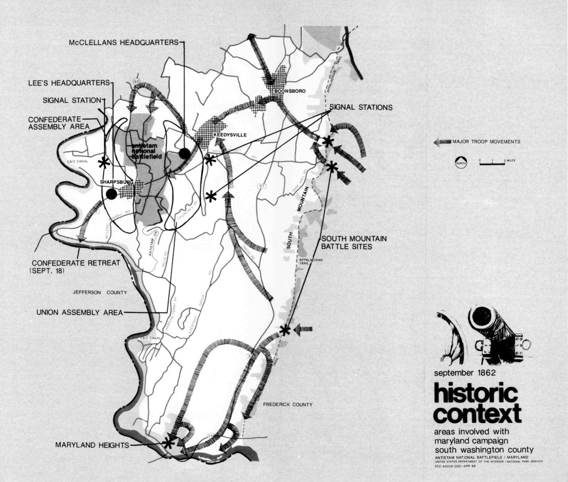
In April 1988 the US Park Service produced a report about the Antietam National Battlefield and surroundings called analysis of the visible landscape [pdf]. Its stated purpose:
Recently, residents and state and local administrators have become concerned that the rural character and lifestyle of south Washington County, including Antietam National Battlefield, are being eroded by poorly planned suburban development. The National Park Service shares this concern because of the potential threat to the agricultural setting which is so important to the historic scene at Antietam. During the summer of 1987, the Maryland Department of State Planning contacted Antietam Superintendent Richard Rambur requesting National Park Service assistance with the South County Study for land use planning. Specifically, the state sought information on which areas contribute to the scenic quality of the battlefield. This report has been prepared in response to that request.
It’s an excellent work which, along with local preservation activism, contributed to increased zoning and easement protections for the land on and near the battlefield. You can easily see the results when you visit the Park today.
I think this map, from that report, is the nicest overview of the geography and military activity of the Maryland Campaign I’ve ever seen, which leads me to share it with you, both of my readers. It was probably drawn by John Ochsner, Landscape Architect at the Denver Service Center, US Park Service.
The dead of Antietam 158 years later
9 September 2020
On the occasion of the battle anniversary this month I’ve taken stock of the AotW database. There may be another lifetime’s work to do in other areas of the Campaign, but I now have a reasonably complete list of the troops who were killed and mortally wounded at Sharpsburg. The first of its kind anywhere, as far as I know. Pretty cool!
I’ve created a couple of new reports on the subject which you can download at the end of this post.

When I count the individuals who were killed outright or were mortally wounded and died on 16, 17, or 18 September 1862 I get 1,653 Confederates (the Official Records say 1,550 were killed) and 2,205 Federals (OR has 2,100).
I’ve also pulled the names of the soldiers who died of their Sharpsburg wounds in the days and weeks afterward. These make an additional 772 Confederates and 980 Federals.
So if you suspected the official numbers were a little low, you were right. As a caution, let me remind both my readers that the records are sometimes awful and occasionally missing altogether, and besides, I’ve certainly not seen every source there is to see. I’m sure I’ll find more names to add.
Also, I need to look at it some more, but there may be enough in my collection to name most of those 5,800+ burials on the newly-identified S.G. Elliott map. Just don’t ask me to guess which of those little marks are which person. I haven’t looked at any others on the map yet [update: see my annotated exhibit on the Elliot map], but the man listed in the map portion above as F.L. Fraser is E. L. Fraser, Private of Company I, 12th South Carolina. Later records of his field burial correlate well with the 1864 Elliott map.
Ok, so just in time for the anniversary, here are 2 versions each of two reports listing the killed of Antietam. As always, if you can add names or improve the information please let me know.
Men Killed in the Battle of Antietam at Sharpsburg, Maryland 16-18 September 1862
Sorted by state | Sorted by rank [3834 names, 1.0 MB pdf]
Men Who Later Died of Wounds from the Battle of Antietam at Sharpsburg
Sorted by state | Sorted by rank [1736 names, 500 KB pdf]
________________
These new lists and the ongoing Dead of the Campaign list are also hosted, and will be updated in the future, under Antietam 150: The Dead of the Maryland Campaign elsewhere on this blog.
The Antietam observation tower and the birth of the Park
1 December 2018
My project on the visual history of the Antietam National Battlefield continues, focused today on one of the most iconic features on the field – the Observation Tower. Since it was built in 1896 the tower has been a central memorial and educational feature of the National Battlefield, and it has always been a popular destinations for visitors.
So how did it come to be, and how has its story evolved in the last 122 years?

It starts with the origins of the battlefield park itself.
